Building Transparency and Added Value into Lead Service Line Discovery and Replacement
Jeffrey Weaver, Director of Digital Solutions
Hodge Patel, Business & Government Strategy Director
George Nikokiris, GIS Specialist
State and federal mandates requiring communities to complete a materials inventory of all water service lines are reaching the leaders of communities large and small across the country. With critical deadlines in Indiana to complete the work by October 2024 looming ahead, the clock is ticking.
For many of our client communities, these requirements are arduous, overwhelming initiatives with significant knowledge and resource challenges. Communities are unsure of where to begin, and when they do kick off their efforts, they’re faced with incomplete or erroneous analog water records, a workload superseding their staff capacity, and a lack of digital tools that would improve speed and ensure data accuracy before submitting their inventories to the State.
Funding through the Indiana Department of Environmental Management (IDEM) and the Indiana Finance Authority (IFA) has enabled third-party consultants like Abonmarche to guide and manage water service line inventory efforts for municipalities. This funding is still available to hundreds of municipalities and public water systems in Indiana for 2024, with the amount available fluctuating depending on the community/water customer size. Communities are eligible for $15,000-55,0000 in non-competitive grant dollars, with no match required. Additionally, there is another $100,000-400,000 in competitive grant dollars available.
Our Digital Solutions team has been supporting many of our client communities as they work toward compliance with the state and federal mandates; however, we’re shooting higher than simply completing the bare minimum inventory requirement.
Our firm’s unique experience in lead service line identification and replacement has realized many additional benefits communities can take advantage of while completing their inventory requirements.
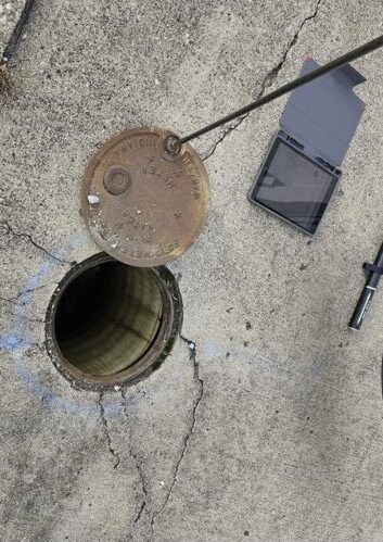
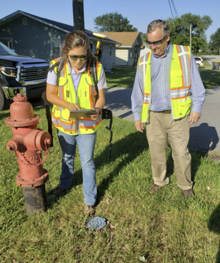
GPS-ing Curb Stops: Abonmarche employees use cutting-edge GPS equipment to collect water asset data in the field, improve the accuracy and completeness of the inventory. Photos of pipes and curb stops are then accessible through an app.
The state of Indiana has set aside $43M each year from 2022-2027 to assist 500 communities across Indiana with their Lead Service Line (LSL) inventories and Lead Service Line replacements. Each community in Indiana is required to submit their Lead Service Line inventories no later than October 16, 2024, and it must be submitted to the Indiana Department of Environmental Management (IDEM). To assist with this, the Indiana Finance Authority (IFA) is offering grants of up to $55K for communities in Indiana that have at least 700 or more water service connections.
In 2023, Abonmarche helped 13 partner communities across Indiana jumpstart their water service line inventory efforts – first by securing grant funding and then putting the funds to work in developing an inventory.
Our firm utilizes a multi-disciplinary approach which allows our clients to benefit from the robust knowledge and expertise of our full team – from Digital Solutions to Engineering, Land Surveying, Planning, and more. In addition to the mandated materials inventory, we’re providing these communities with meticulously designed, added-value resources, including:
Historical Records Digitization. Safely archive documents in digital form, prepare those documents for further data analysis, and scan the documents into GIS data maps and field map applications, allowing stakeholders to view and access these historical documents from an iPad any time, at any location, at any time.
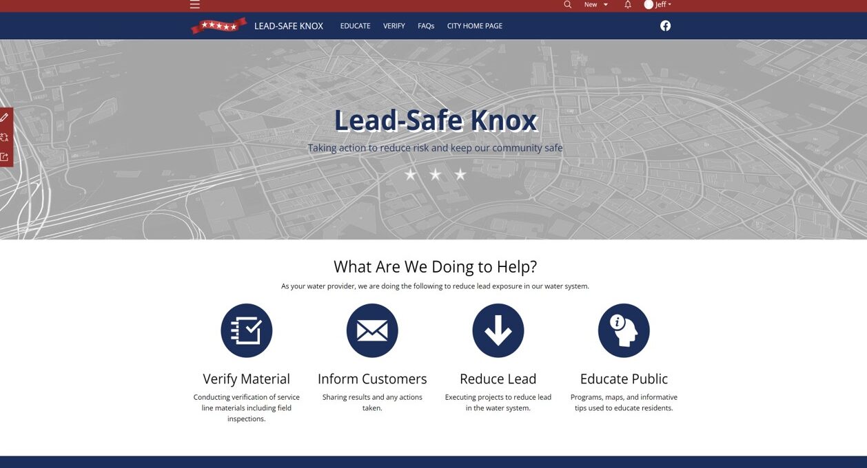
Project Delivery Sites. As an ESRI business partner, we can offer clients an ESRI ArcGIS online platform used to host their community’s GIS data and provide their residents with a cloud-hosted, 24/7 accessible micro-website that keeps everyone up to date on project progress. These hub sites are easy-to-configure and can be be utilized as community engagement platforms that organize people, data, and tools through information-driven initiatives – offering engagement through surveys, education, and FAQs about the lead service line inventory initiative. Think of it as a simple website for public consumption. Each community’s hub site is designed to reflect its unique messaging, logo, and other branding elements.
Community Engagement. Our team develops comprehensive engagement plans and best practices that reach all residents. We work closely with each community to identify their engagement needs and guide the messaging to reflect their culture and connect with their residents. Engagement solutions include education on best practices, communication pieces such as door hangers, flyers, mailers, and inserts for utility bills, and careful consideration of area-specific qualities like the need for bilingual messaging across materials.
Data Conversion of Original Water GIS Data. Conversion of original water GIS data into LGIM (Local-Government-Information-Model) data standards improves the performance, storage, and overall design/structure of the data, making it easier to use.
GPS-ing Curb Stops. Using GPS equipment for field-collection of water assets, such as piping and curb stops. Abonmarche employees use cutting-edge GPS equipment to collect water asset data in the field to improve the accuracy and completeness of the inventory. Photos of pipes and curb stops are stored with GIS data points accessible through an app.
Home Visits. If a community needs boots-on-the-ground support, our team can assist in making door-to-door home visits to conduct tests on service lines at residences that have yet to be inventoried.
LSLI Suite of GIS Apps. Our Digital Solutions team offers a full suite of GIS applications to help communities continue their inventory efforts into 2024. Solutions include dashboards for project management, desktop applications for administration functions, and field maps for contractors.
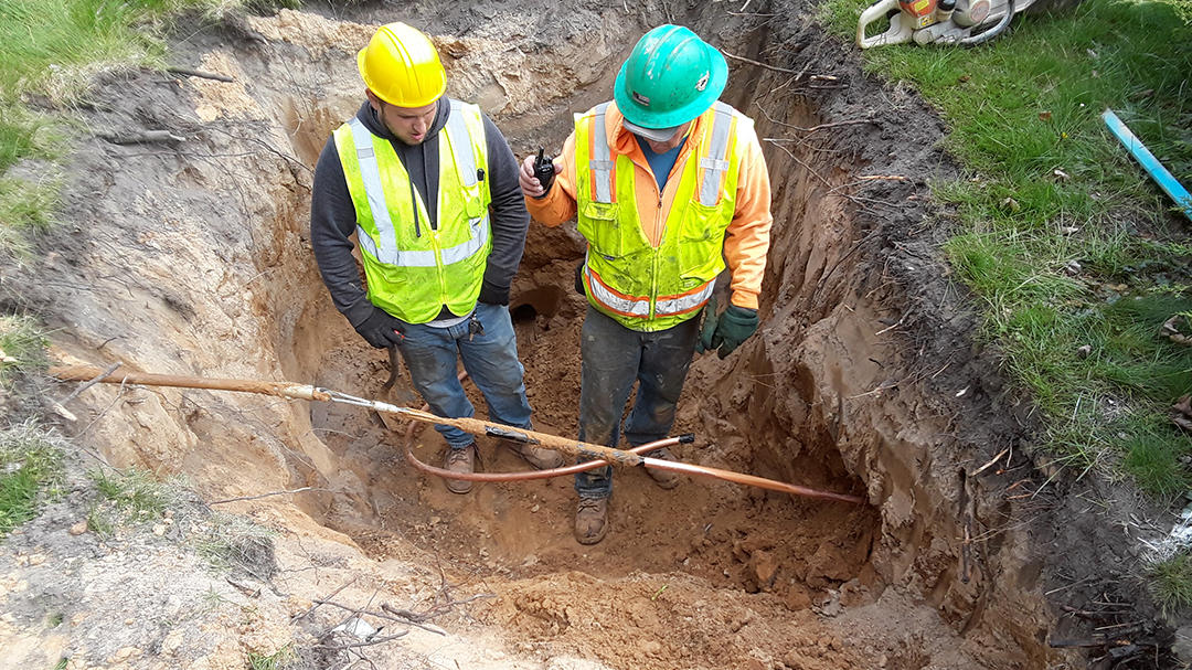
Hydro-excavating. Our firm is currently working with our clients to provide direct identification of service line material through hydro-excavating (aka potholing). Through the hydro-excavating process, we develop a system analysis to identify the best locations to hydro-excavate that will provide the most information, then support the management and oversight of contractors performing the work.
Communities have the option to use a cloud-hosted, 24/7 accessible micro-website that keeps everyone – from contractors and residents to community leadership – up to date on project progress.
How Your Community Can Prepare for Lead Service Line Inventory & Replacement Requirements
Abonmarche has developed a Geographical Information System (GIS) based set of inventory identification and collection apps and tools that can integrate with your existing GIS. It also includes a customizable customer support site that exceeds State requirements for reporting to the public. If our clients don’t have a GIS, Abonmarche can provide it, utilizing the available grant funding from the Indiana Finance Authority (IFA) to get the inventory up and running. In the meantime, we recommend communities take the following proactive steps to prepare for their water service line materials inventory:
Identify your existing lead service line (LSL) data. If you do not have an existing service line inventory, begin the process by gathering historical system records and information to develop an initial inventory. If you do have one, cross-check your current inventory against the new requirements and start updating your existing inventory. Take advantage of ongoing opportunities to collect data in the field, such as when performing meter replacements or main repairs and replacements.
Identify supporting data for your LSL inventory. Supporting data such as water main age, building age, and meter information can be used to build your LSL inventory. If you have this data available, make sure that it is up-to-date and is as accurate as possible.
Initiate discussions to accomplish full LSL replacements. For many systems, achieving full LSL replacement can be a challenge. Begin to explore and identify replacement programs and funding options, including assistance programs for customers who are unable to pay to replace their portion of the service line. Discuss factors to prioritize replacements, such as targeting areas with vulnerable populations or disadvantaged customers.
Prepare for rapid notification. Understand the various engagement timeframes and delivery methods. Begin developing the required notification materials and coordinating with the appropriate departments and adjacent organizations.
To learn more about how our team can help your community complete its water service line material inventory requirement on time – and ensure your effort becomes a valuable investment in the future – contact Hodge Patel, Business & Government Strategy Director at: hpatel@abonmarche.com or 574.304.2905.
Streamlining Water Management | A Digital Transformation for the Town of New Chicago, Indiana
In a world where digitalization has become the norm, there are still pockets of resistance where analog and legacy work processes hold strong. The town of New Chicago, with a population of 1,980 people, stood as a testament to this reluctance to change. The town’s records, infrastructure data, and operational processes were firmly rooted in pen and paper, and even the idea of digitizing seemed far-fetched. This is where Abonmarche stepped in, facilitating a digital transformation that has revolutionized the way New Chicago manages its water assets.
The Legacy Systems Challenge
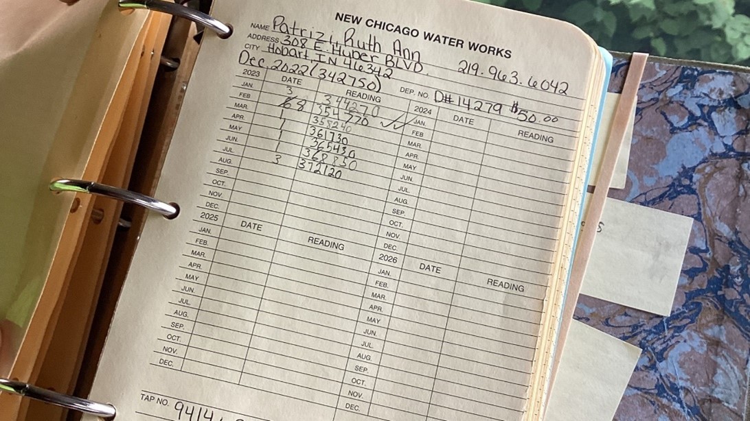
With all records existing on old maps and index cards, the town faced challenges in efficiently managing its water distribution system. The population might be small, but the complexity of its water system is significant. New Chicago’s antiquated water meter books, comprising a staggering 13 binders, were a symbol of the challenge ahead.
The most significant challenge was the lack of readily accessible and reliable asset data. Knowledge about main lines, valves, and service lines was confined to maps from the 1990s, and when field workers encountered problems like leaks, they had to trek back to the facility to cross-check asset data. This process resulted in inefficiencies and frustration among the crew. Handwritten notes containing crucial information about asset attributes were often illegible, causing further complications.
A Digital Transformation Emerges
Recognizing the urgency for change, Abonmarche’s Digital Solutions team embarked on a journey to modernize New Chicago’s water management systems. The approach was innovative yet simple: ‘heads-up digitizing.’ This method involved recreating the entire water distribution system within the Esri ArcGIS platform, effectively transforming the data from analog to digital.
Within a few short weeks, the team completed this work, with transformative results:
1. Unleashing Digital Capabilities: The data was no longer confined to physical maps; it could now be downloaded, exported, and shared online. This open access unlocked capabilities that were previously unthinkable.
2. Empowering Field Workers: Field crews could now access the data they needed directly on tablets while out in the field. This eliminated the need for them to return to the facility to make decisions, improving efficiency and reducing operational delays.
3. Seamless Data Accessibility: The establishment of a project delivery site (Esri ArcGIS Online Portal) for the Town of New Chicago brought the power of digital data storage to the cloud. Information is now available 24/7, enabling real-time decision-making.
Bridging the Gap with Mobile Devices
The integration of the town’s digital map into a tablet app allowed field crews to manipulate and interact with the data directly from their devices. This move brought several notable benefits:
On-the-Spot Edits: Field crews can make necessary edits onsite, eliminating the need to process changes back at the office. This streamlined workflow ensures accuracy and reduces response times.
Effortless Application of Edits: With just a few taps on their tablets, crew members can seamlessly apply edits to the digital map, enhancing data accuracy and minimizing errors.
Innovative Mobile Device Equipment Leasing Program: At the heart of this program is our commitment to seamless tablet management for these communities. Instead of worrying about app deployments, iPad tracking, or the headaches of replacements due to loss or theft, our client communities can participate in our mobile device leasing program for just $55 per month, per iPad user – letting our team shoulder the responsibility of technology management.
Revolutionizing Meter Readings
The digital transformation didn’t stop with the water distribution system. New Chicago’s monthly meter readings, once documented laboriously in antiquated meter reading books, underwent a similar transformation.
The field crew’s process of manually recording readings in large, unwieldy books was replaced with a streamlined app developed by the Abonmarche Digital Solutions team. This app revolutionized the client’s process in several ways:
Account Number Integration: The addition of account number information to each property brought organization and structure to the meter reading process.
Consolidation of Data: The Digital Solutions team combined hundreds of account numbers tied to New Chicago’s addresses into a single, accessible source.
Field Map Integration: The app’s interface presented line items within a field map, enabling crews to input readings and attach photos to data points effortlessly.
Rainproof Efficiency: Unlike the physical books susceptible to rain, the tablets used by the field crews are waterproof, allowing them to work unhindered by weather conditions.
A Bright Digital Future for New Chicago
In the end, the transformation brought about by Abonmarche positioned the town of New Chicago for a brighter, more efficient future. The benefits were immense:
Efficient Field Work: Streamlined workflows and onsite decision-making maximized the crew’s time in the field, resulting in faster response times.
Web Accessibility: The digital data was effortlessly shareable on the web, enhancing communication and collaboration across departments.
Digital Records: Records and information were now stored securely in a digital format, eliminating the risks associated with physical books.
“This has opened up capabilities to us like never before,” noted the Water Superintendent of New Chicago. “I always had to come back to the office and sift and search through those old, worn-out water maps. Now, all the information I need is right here in the field with these tablets. This is amazing! This will help our crew do our job faster just by having the knowledge of where everything is located while we are onsite.”
This project demonstrates the impact of digital transformation. With streamlined workflows and improved technology, New Chicago can now participate in efficient, data-driven water management that facilitates better communication between team members. This success story serves as an inspiration for other communities looking to embrace the possibilities of digital investment.
Lead Service Lines | Data Transparency for a Community in Action
Benton Harbor has committed to replacing all lead service lines within 18 months. This photo shows field staff performing a replacement.
Along the coast of Lake Michigan, the city of Benton Harbor, Michigan, has, until recently, faced steep resource challenges in completing a much-needed, large-scale lead service line replacement project.
Benton Harbor is not alone in the challenge it faces in replacing existing lead service lines. Lead service lines are still prevalent across the country and in the State of Michigan in particular.
According to the National Resources Defense Council (NRDC), “As many as 12 million lead pipes — and possibly more — carry drinking water to the homes of up to 22 million or more people across the country.” These lead service lines have long been recognized as the primary contributor to lead in drinking water.
Benton Harbor’s water distribution system is more than 100 years old, and many homes were built before the 1960s. Water from the city’s water plant doesn’t have lead in it; however, many of the water service lines from the property line to the homes are made of lead or have lead components, as do some public water service lines.
Benton Harbor Mayor Marcus Muhammad, Contractor Donnie Meeks, and U.S. Representative for Michigan, Fred Upton, onsite in Benton Harbor, Michigan.
With funding from the Environmental Protection Agency (EPA) and the state of Michigan — and a commitment from Michigan Governor Gretchen Whitmer to replace all service lines within 18 months — the rejuvenated replacement project kicked off in early November 2021. The city engineering firm for Benton Harbor, Abonmarche, set about coordinating lead service line replacement efforts for a project that would be operating for many months at a break-neck pace.
Abonmarche’s goal was to create a solution to track and share the progress of a large and fast-moving lead service line replacement project. As an added benefit of the project, data collected will be incorporated into the comprehensive asset management program being developed for the city.
By blending Abonmarche’s digital solutions expertise and solid foundation of geographic information system (GIS) knowledge and experience into our engineering work, we were able to elevate this high-profile project to an efficient, successful operation that demonstrates best practices. The model and approach we are developing for Benton Harbor will serve as a precedent for future projects in other communities across the Midwest.
Implementing Esri’s Lead Service Line Inventory Solution
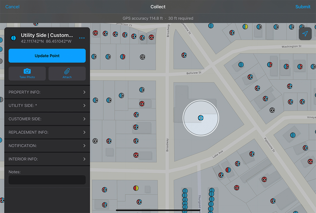
Deploying an Esri Architecture, Engineering, and Construction (AEC) Project Delivery service and ArcGIS Online for the city, Abonmarche was able to quickly set up a water service line inventory. The deployment was based on existing water account records, record inspections, and previously identified replacements, making use of Esri’s ArcGIS Field Maps mobile app. Data was then shared with the public in real time through the ArcGIS Hub community engagement site and associated dashboard.
The dashboard and hub site have changed the face of a critical community health initiative. Benton Harbor’s ability to share accurate, up-to-date information with the public has established transparency from the project’s onset, setting a foundation for building trust.
Abonmarche used Esri’s Lead Service Line Inventory solution as a base framework to configure and customize the project’s specific needs and goals. This industry-specific solution helped to easily set up the necessary data layers, maps, and applications, enabling Benton Harbor to go above and beyond to communicate with the community.
“Working in GIS was the perfect solution for this type of project. We wanted something thorough and reliable, yet easy to deploy in order to keep up with the pace of the project. Seeing inspections and construction results in real time has been key to monitoring issues as well as sharing results. Recording and publishing the progress with GIS has been so much more efficient than the processes of the past.”
Garrick Garcia, GIS Technician, Abonmarche
Esri’s Lead Service Line Inventory solution came with a number of built-in maps. Abonmarche configured those maps to fit the project’s requirements, then integrated them into the ArcGIS Field Maps mobile app to become part of the final workflow solution. Then, using the Project Manager Web App from the ArcGIS Solutions collection, Abonmarche designed the ability to track which service lines have been replaced, which service lines have yet to be replaced, and a host of other valuable information. Finally, several custom web applications and dashboards were created to interact with the out-of-the-box solutions apps so that additional project requirements could be easily managed. This suite of web maps and applications has provided contractors, inspectors, project managers, and office administrators with the ability to communicate directly and coordinate the work that is being performed.
The ArcGIS Field Maps mobile application is the key piece for logging mobile work into the GIS.
The hub provided by the Esri solution was a great template that was modified to show the information the city wanted. Multiple pages were added to the site with embedded content and links to informational PDF documents and required forms.
Meeting Project Goals
Alongside the Lead Service Line Inventory solution, the Abonmarche team implemented a host of other supporting Esri solutions and applications. This provided a strong foundation to jump-start the project while required customization and applications were being developed to meet all of Benton Harbor’s organizational goals. Various applications and dashboards were created to provide the ability to
Organize and track all the required Right of Entry (ROE) permission forms, as well as all feedback received from the community about the project.
Log mobile work into the GIS.
Enter service line information into the GIS from the office environment.
Quickly track work that was being done and categorize that work to quantify the results for informative purposes.
Share real-time data with the public in an easy-to-digest method.
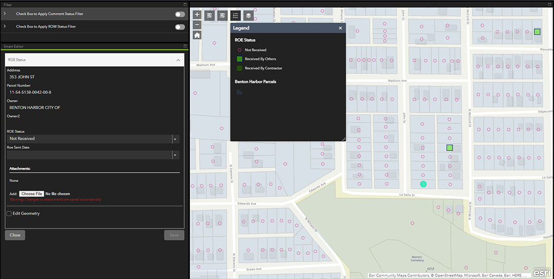
The Administrative Desktop App is used for Right of Entry form tracking. Lead service line replacement cannot be completed on private property without an ROE form.
Administrative Desktop App
The custom Administrative Desktop App enables the project team to organize and track all required Right of Entry permission forms, as well as all feedback received from the community about the project. As part of the process of updating service lines, the City of Benton Harbor is required to collect a Water Service Line Agreement Form from each property owner, granting permission to enter the property and complete the service line replacement work. Once a permission form is completed, the data is collected in an app that will then be accessed directly by the contractors, letting them know that they can move forward with work on each property.
To develop this app, Abonmarche took the concept of the Office Editor Web App (used to administer all data and work being performed) and refined the editing tools and pop-ups to only display and edit fields pertinent to the information office administrative staff would be receiving from property owners. Two new view layers were created—Right of Entry and Comments—each with a unique symbology to show the ROE status and if the comments were addressed. Each view layer only displays and allows the editing of selected fields. In the app, each layer can be turned on or off depending on what information the person inputting data is receiving.
When editing the Right of Entry layer, the editor tool enables staff to indicate when an ROE form was sent and whether it was received and also upload a copy of the form as an attachment.
To track comments, a related table was set up that can log multiple comments for one address. The related table shows up in the editor tool when editing the comments layer and allows new comments to be logged. The layer is symbolized by a field designating if the comments have been addressed or not.
This app ensures the integrity of data by providing users with exactly what they need and ensuring that each user can only update what is required.
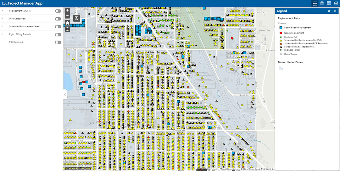
The Project Manager Web App is used to track Right of Entry permissions.
Project Manager Web App
Using the built-in framework included in the Lead Service Line Inventory solution, project managers can track if an ROE form was received for every property. A Right of Entry form allows the contractor to enter a residence to make a final service line connection. Without this permission, work cannot be completed. Knowing which homes have given ROE permission is an essential tool for this project. Using ArcGIS Pro, Abonmarche was able to load the web map that feeds the Project Manager Web App, then use the expression builder to code a unique symbology expression to display scheduled replacements—and if an ROE form was received or not. This allows scheduling which replacements can be made, ensuring that the field crews and inspectors are performing the correct work on the correct asset.
Field Maps Mobile App
The ArcGIS Field Maps mobile application is the key piece for logging mobile work into the GIS. Web maps are set up for both contractors and inspectors that can be viewed and edited within the Field Maps mobile app. Using view layers enabled only fields relevant to the data collector to be displayed, and the forms feature within Field Maps allows the data entry fields to be organized into categorized drop-down menus for quick navigation and legibility. Collecting data at the point of inspection with Filed Maps is the driver for the rest of the data sharing and publishing abilities. Data integrity and data quality are maintained through required fields and domain values.
Office Editor Web App
The Lead Service Line Inventory solution provided an excellent tool for entering service line information into the GIS from the office environment. Whenever existing records are received or new data insights are made, they can be easily entered into the Lead Service Line Inventory by office staff. The tool can also be used to correct errors that may have occurred with mobile data inputs. Like the Project Manager Web App, symbology was updated to show some unique customer-side statuses, including “customer-side not constructed” or “out of scope” because there was no current customer. The web map that feeds the Office Editor Web App was loaded into the ArcGIS Pro desktop program and the expression builder was used to set a new unique symbology as well as update the symbology template displayed on the editor tool in the web app. The Office Editor Web App is used to administer all data and work being performed within the Lead Service Line Replacement program.
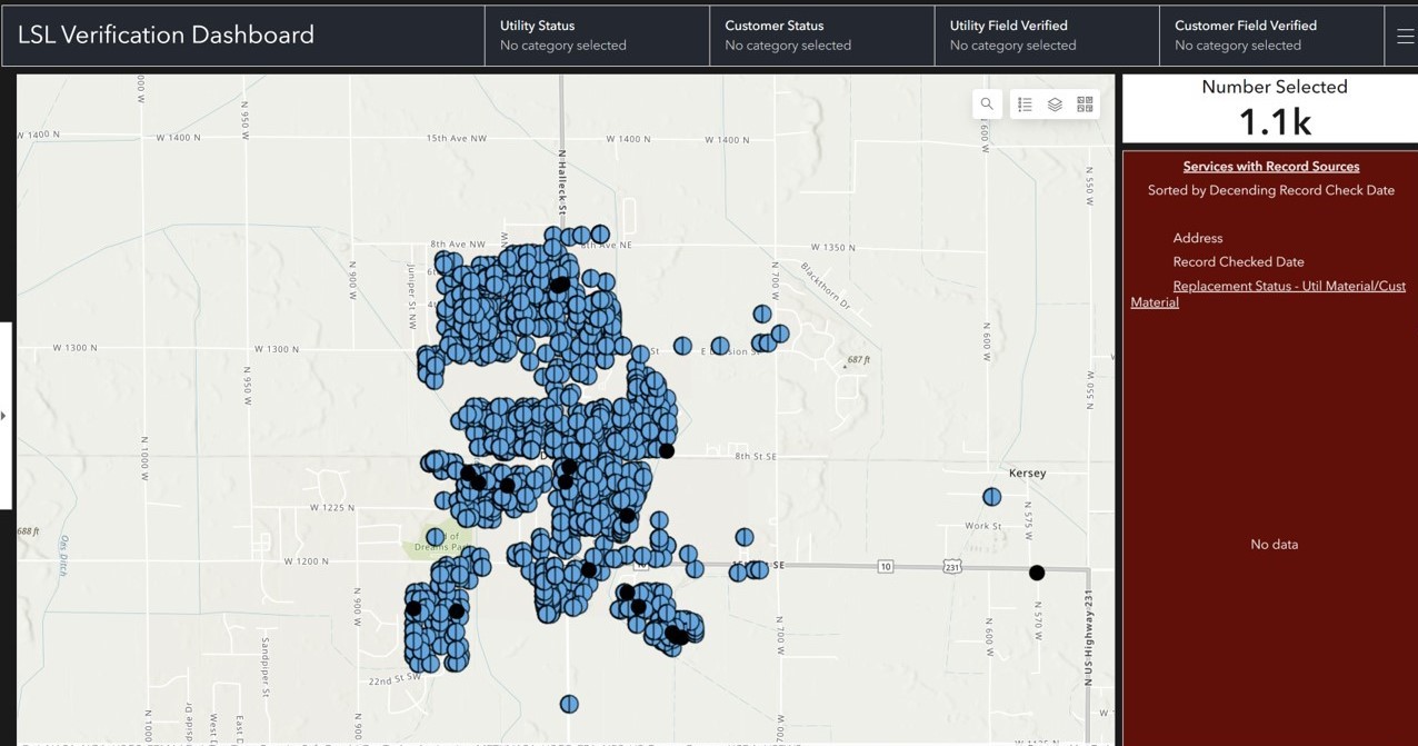
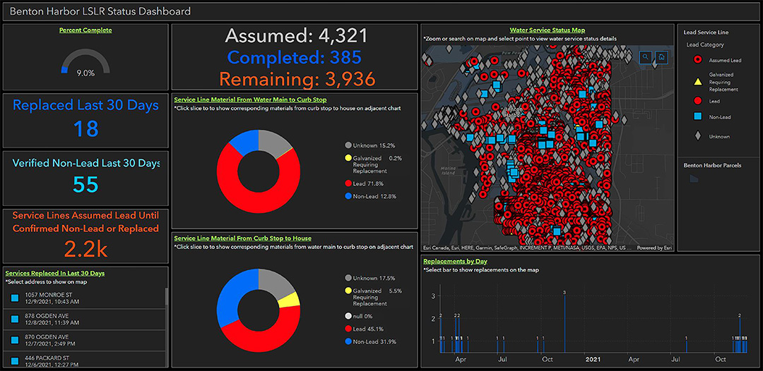
The Service Line Recent Verification tracking dashboard enables staff to quickly track work that is being done and to categorize that work to quantify results for informative purposes.
Recent Verification Tracking Dashboard
One of the top goals was to be able to quickly track work that was being done and categorize that work in order to quantify the results for informative purposes. Esri’s list widget enabled data shown on the map to be sorted by verification date, which will always show the most recent inspection at the top, listing the address and date. An indicator widget above that list displays the number of services shown on the map. Then, we applied a series of category filters that provide the address, number of services in that category, and map locations for any given category. This has been useful in making quick data checks and ensuring that any issues are identified early before they can become a problem.
Real-Time Data and Real-Time Transparency for a Community in Need
The Esri solutions implemented enabled the data to be tracked digitally and more accurately in a way that made the most sense. It also allows Benton Harbor to share real-time data with the public in an easy-to-digest method.
The dashboard, available on the City of Benton Harbor website, is updated in real time to reflect current progress and includes a map with the location of each house, along with two charts showing the materials each service line is made of on the city side and customer side. The dashboard also shows the dates and addresses of the service lines replaced in the past 30 days, offering a valuable monthly snapshot to the community.
The lead service line replacement dashboard, available to the public around the clock. enables Benton Harbor to share real-time data with the community in an easy-to-digest method.
“Once we published the project dashboard, we immediately received favorable responses from state, local, and federal agencies and various media outlets about how helpful it was to them for their functions regarding the project,” says Jason Marquardt, senior project manager at Abonmarche. “It has been a great resource that was easy to implement and will be a key tool for this project as we see it through to completion.”
“This Lead Service Line Inventory solution has saved our team and Benton Harbor hundreds of valuable hours that can now be spent in other ways. Without using GIS and its accompanying apps and tools, our contractors would be manually filling out forms and sending them to us in bulk; our team would have to then parse through and manually input that data into a spreadsheet to compare with our list of active accounts and manually generate weekly reports of work done,” says Garrick Garcia, GIS technician at Abonmarche.
“There is a tremendous amount of forward momentum to getting these pipes out of the ground as a key part of removing the threat of lead from the city’s drinking water,” Benton Harbor Mayor Marcus Muhammad said in a press announcement shortly after the dashboard went live. “This dashboard gives residents a window into the aggressive work being done throughout the city.”
“I believe the state-of-the-art Lead Service Line Replacement dashboard is an outstanding example of how technology can provide continuous up-to-date information to the public on whatever they want to know about what is happening with a project like the City of Benton Harbor’s Lead Service Line Replacement program,” added Alex Little, Director – Community & Economic Development / Assistant City Manager at the City of Benton Harbor. “The city is pleased to have this resource available to the public on our website.”
Using the new system, all work is shown in real time, updates on work completed are shown instantly, and the GIS data can be used to autogenerate any needed documentation. We now have the ability to work digitally and communicate more accurate data, quicker. We can now show the public our tangible progress — eliminating paper updates, transposing information, and avoiding redundant data entry, so that citizens can see the work happening in real time.
This article is also published on the ESRI website, viewable at: